First of all, we’d like to thank Sam Milton-Dixon for designing our new logo.
The Lea, Cleverton and Garsdon Rights of Way Group are active throughout the year repairing and maintaining the footpaths in the area of Lea, Cleverton and Garsdon. For many years there has often been just the one person fulfilling this role, which must have taken a great deal of effort to keep on top of the all the footpaths that stretch north beyond Garsdon, west to the weir by Crabb Mill, East to Malthouse Farm and bounded by Brinkworth Road. Although I’ve walked most of the paths many times, I’ve no idea how many miles are involved. I have thought about using the Ordnance Survey app to calculate the total distance of all the paths.
A group of people walked every path back in April 2021. The group included Steph Isaac, Linda Simpson, Chris Beeby, Stuart Suter, and myself, and led by Christopher Daws, put together a document detailing every path and every issue encountered on our walks. This was a monumental effort to transcribe all the information, which amounted to all our knowledge of the footpaths in the area.
A couple of months later, prompted by Stuart Suter, a new Rights of Way Group was formed, and I was elected as the footpath secretary for the group. Over the summer, as a group of volunteers, we repaired a stile at School Lane and two at Brillscote farm, cleared the Spinney on the bridle-path south of Cresswell Lane, and removed fence and stile, and repaired steps at St.Giles Church. The latter was particularly satisfying, as removing a stile, and replacing with a gap, allows a broader range of walkers, who might otherwise find it difficult to access the path. We’d like to thank all the people who worked with us together on these activities.
Probably our biggest ongoing challenge is brush-cutting the paths in order to keep them open. Certain paths, such as those to Malmesbury, are to some extent, kept open by the many walkers using these paths, but the majority are less frequented, and many look rather forlorn. This is a shame, as even some of our major paths providing circular routes to neighbouring villages such as Charlton and Little Somerford can be difficult in places to pass. You can understand a landowner may not bother ensuring a right of way is passable if it is hardly used. As the Ramblers Association often quote ‘Don’t Lose Your Way’.
One possibility under consideration is to ‘Adopt a Path’, where, rather than walking the same path every day, a person might choose one of the ‘forlorn’ paths and report all issues observed. I think once a month walking a path would be regular enough to monitor its state.
Please contact me (details below) if that would be of interest.
During autumn and over winter, we continued in smaller groups repairing stiles including those at Little Badminton Lane, and Rushcroft Close, working with the Carol and Stuart Gray in Cleverton to improve the muddy gate on the bridle-path, with Andy Taylor on the paths from St.Giles Church to the B4042, and yet more brush-cutting throughout the area.
In May we were busy at Park Lane in Garsdon and as far as Heath Farm repairing stiles and bridges and brush cutting along paths Lecl19 and 31. There has been a recent hiatus due to the particularly hot weather. We will be continuing soon as we have plenty of repairs in the pipeline, so if you would like to volunteer, my details are below.
Stephen Carroll.
Footpath Secretary
Email: stephenapcarroll@hotmail.com
Rights of Way
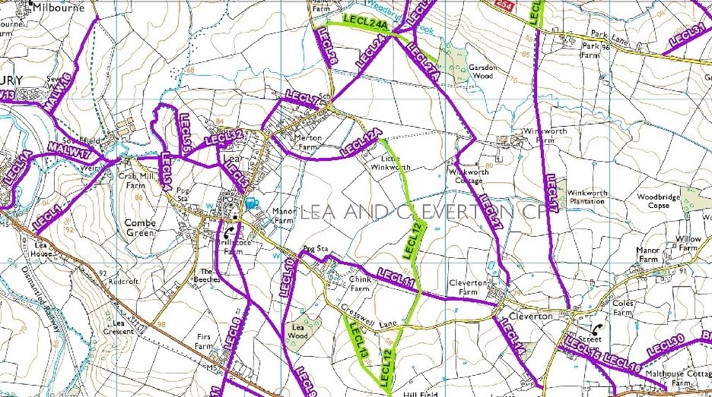
The Footpaths and Bridleways shown on the map are there for the enjoyment of everyone. However users should at all times stay on the designated routes across farmland and keep their dogs under control. This is especially so where livestock are in the fields that are crossed by footpaths as loose dogs can cause distress and harm to the animals.
The map below shows the Rights of Way within the Parish of Lea, Cleverton and Garsdon. This map is an excerpt from the Wiltshire Council Definitive Map. Path numbering consists of the Parish identifier followed by a number. For example, a path denoted ‘Lecl’ refers to the Parish of Lea, Cleverton and Garsdon, whereas ‘MALW’ refers to paths within the Parish of Malmesbury.
The map below shows the Rights of Way within the Parish of Lea, Cleverton and Garsdon. This map is an excerpt from the Wiltshire Council Definitive Map. Path numbering consists of the Parish identifier followed by a number. For example, a path denoted ‘Lecl’ refers to the Parish of Lea, Cleverton and Garsdon, whereas ‘MALW’ refers to paths within the Parish of Malmesbury.